
Watch short for this article (5 slides)
Decoding the Fury: Understanding Rapid Hurricane Intensification and Its Growing Threat
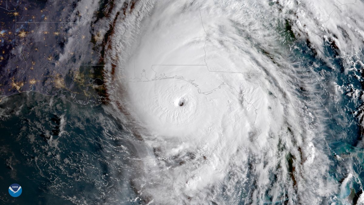
Hurricane Beryl's record-shattering intensification in 2024 served as a stark reminder of the explosive power tropical cyclones can unleash. Witnessing a tropical depression or storm rapidly escalate into a major hurricane (Category 3 or higher on the Saffir-Simpson Hurricane Wind Scale) underscores a critical challenge in meteorology and public safety: understanding and predicting rapid intensification (RI). This phenomenon, where a storm's maximum sustained winds increase dramatically in a short period, significantly shortens preparation times and escalates potential impacts. This article delves into the complex atmospheric and oceanic mechanisms driving RI, examines why it appears to be occurring more frequently, explores the challenges in forecasting it, and outlines essential preparedness measures.

Watch video summary:
What Exactly is Rapid Intensification? Defining the Threshold
Rapid Intensification isn't just a subjective term for a strengthening storm. The U.S. National Hurricane Center (NHC) defines RI as an increase in the maximum sustained winds of a tropical cyclone of at least **30 knots (approximately 35 mph or 55 km/h) in a 24-hour period**. Achieving this benchmark requires a specific and often finely balanced set of environmental conditions to align perfectly, allowing the storm's internal engine to roar to life.
The Engine Room: Key Ingredients for Explosive Growth
Several critical factors must converge for a tropical cyclone to undergo RI. These elements provide the necessary energy, structure, and atmospheric support for the storm to rapidly consolidate and strengthen its core.
1. High Ocean Heat Content (OHC) - The Primary Fuel Source
While warm sea surface temperatures (SSTs) are fundamental, the *depth* of the warm water is arguably more crucial for RI.
- Sea Surface Temperature (SST): Generally, SSTs must be at least **26.5°C (79.7°F)** to provide sufficient heat and moisture flux through evaporation to sustain a tropical cyclone. However, RI often requires significantly warmer temperatures, typically exceeding **28.5°C (83.3°F)**.
- Ocean Heat Content (OHC): This measures the total heat stored in the upper ocean. A deep layer of warm water prevents the storm's own strong winds from churning up colder water from below (upwelling), which would otherwise cut off its energy supply. High OHC, often quantified by Tropical Cyclone Heat Potential (TCHP), provides a sustained, high-octane fuel source allowing the storm to feed continuously and intensify rapidly. The exceptionally high OHC observed in parts of the Atlantic in 2024 was a major contributor to Beryl's strength.
"Think of high OHC not just as fuel on the surface, but a deep, readily available fuel tank that prevents the storm from running out of gas as it strengthens." - Metaphorical explanation based on NOAA principles.
2. Low Vertical Wind Shear - Maintaining Structural Integrity
Vertical wind shear refers to the change in wind speed and/or direction with height in the atmosphere.
- Impact of High Shear: Strong wind shear acts like an atmospheric sledgehammer. It tilts the storm's vertical structure, displaces the warm core aloft relative to the low-level circulation, and ventilates heat and moisture away from the center, disrupting the organization needed for intensification.
- Favorable Conditions for RI: Low wind shear, typically **less than 15-20 knots (17-23 mph)** between the upper and lower troposphere, allows the storm's vortex to remain vertically stacked. This alignment is critical for efficient energy concentration and pressure drop in the core, enabling winds to increase rapidly.
3. Abundant Mid-Level Moisture - Sustaining Convection
A moist environment, particularly in the middle levels of the troposphere (roughly 10,000-20,000 feet), is essential.
- Role of Moisture: Moist air fuels the tall thunderstorms (convection) that form the eyewall and rainbands. It prevents dry air from being drawn into the storm's circulation (entrainment). Dry air entrainment promotes evaporation, which cools the air and weakens the updrafts, hindering intensification.
- Optimal Conditions: High relative humidity (often above 60-70%) through a deep atmospheric layer surrounding the storm allows convection to thrive and the storm to expand and consolidate efficiently.
4. Latent Heat Release - The Power of Condensation
This is the fundamental process converting oceanic heat energy into atmospheric kinetic energy (wind).
- The Process: As warm, moist air spirals into the storm and rises, it cools. The water vapor within it condenses into cloud droplets and ice crystals. This phase change releases a tremendous amount of energy known as latent heat.
- Impact on the Storm: This released heat warms the core of the storm, making it much warmer than the surrounding environment. This warming lowers the surface pressure at the center. The steeper the pressure drop (a stronger pressure gradient between the center and the periphery), the faster the air rushes inward and spirals upward, resulting in stronger winds. Efficient latent heat release in a well-formed eyewall is the powerhouse driving RI.
5. Favorable Internal Storm Structure
Beyond the environment, the storm's own internal dynamics play a role. A well-defined, compact inner core, particularly a fully formed eyewall, is often a precursor to RI. However, processes like Eyewall Replacement Cycles (ERCs), where an outer eyewall forms and chokes off the inner one, can temporarily halt RI but may lead to a larger and sometimes ultimately stronger storm after the cycle completes.
Is Rapid Intensification Becoming More Common? The Climate Change Connection
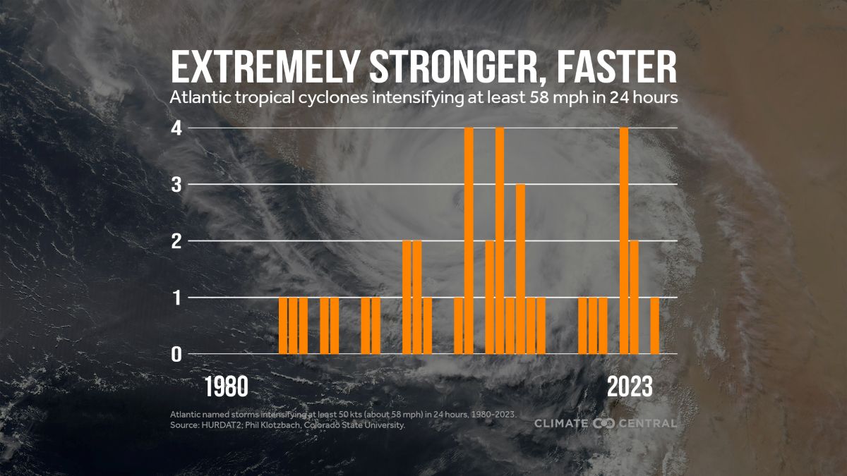
Observational data and climate model projections increasingly suggest that RI events may be becoming more frequent and intense, a trend linked to anthropogenic climate change.
- Warmer Oceans: The most direct link is through rising global ocean temperatures. Warmer oceans provide more fuel (higher OHC), increasing the *potential* intensity a storm can reach and making the conditions required for RI more readily available over larger areas and for longer periods. (NOAA Research on Climate Change and Hurricanes)
- Atmospheric Moisture: A warmer atmosphere can hold more moisture, potentially increasing the available fuel for latent heat release, although regional atmospheric drying trends can complicate this picture.
- Scientific Consensus: While attributing any single event solely to climate change is complex, the scientific consensus, reflected in reports like the IPCC Sixth Assessment Report, indicates that the *proportion* of tropical cyclones reaching higher intensities (Category 4 and 5) and potentially undergoing RI is expected to increase globally with continued warming.
The rapid intensification witnessed in storms like Patricia (2015), Michael (2018), Laura (2020), Ida (2021), and Beryl (2024) serves as potent examples of this phenomenon in action, often catching coastal communities with less time to prepare for devastating impacts.
| Hurricane | Year | Approximate Peak RI Rate | Notes |
|---|---|---|---|
| Patricia | 2015 | ~105 knots (120 mph) in 24 hrs | One of the most extreme RI events recorded globally (Eastern Pacific). |
| Michael | 2018 | ~45 knots (50 mph) in 24 hrs before landfall | Intensified to Cat 5 just before striking Florida Panhandle. |
| Laura | 2020 | ~55 knots (65 mph) in 24 hrs | Rapidly strengthened over Gulf of Mexico before Louisiana landfall. |
| Ida | 2021 | ~55 knots (65 mph) in 24 hrs | Underwent RI twice, reaching Cat 4 before Louisiana landfall. |
| Beryl | 2024 | ~70 knots (80 mph) in 24 hrs | Record RI rate for its location/time of year in the Atlantic Main Development Region. |
The Forecasting Challenge: Predicting the Unpredictable?
Forecasting RI remains one of the biggest challenges in operational hurricane prediction, despite significant advancements.
1. Why is RI Hard to Predict?
- Scale Mismatch: RI is driven by processes occurring at small scales within the storm's core (e.g., eyewall convection bursts) that are difficult for current large-scale weather models to fully resolve or predict accurately.
- Sensitivity to Small Changes: Minor variations in oceanic heat content, wind shear, or atmospheric moisture patterns can be the difference between steady intensification and explosive RI.
- Data Scarcity: Observing the crucial upper-ocean heat content and the detailed 3D structure of the atmosphere and storm core over the vast ocean remains difficult, although improving.
2. How Do Meteorologists Track and Forecast Intensification?
- Satellite Imagery: Geostationary and polar-orbiting satellites provide continuous monitoring of cloud patterns, structure (e.g., using microwave sensors to see through clouds), and intensity estimates (like the Dvorak technique).
- Aircraft Reconnaissance ("Hurricane Hunters"): Specially equipped aircraft fly directly into storms, deploying instruments called dropsondes that measure temperature, humidity, pressure, and wind profiles vertically through the storm. They also use radar to map the storm structure. (NOAA Hurricane Hunters)
- Ocean Buoys and Floats: Provide vital in-situ measurements of SST, wave heights, and sometimes subsurface ocean temperatures.
- Numerical Weather Prediction (NWP) Models: Sophisticated computer models simulate atmospheric and oceanic conditions. Specialized hurricane models (like HWRF and the newer HAFS - Hurricane Analysis and Forecast System) are constantly being improved with higher resolution and better physics to capture intensification processes.
- Statistical Models and AI: Statistical guidance based on historical storm behavior (like SHIPS - Statistical Hurricane Intensity Prediction Scheme) and emerging AI/Machine Learning techniques are used alongside NWP models to improve intensity forecasts.
While forecast *track* accuracy has improved dramatically over decades, *intensity* forecast accuracy, especially for RI events, has lagged. However, ongoing research and investment in observational platforms and modeling are steadily improving capabilities.
Living with Rapid Intensification: Preparedness is Non-Negotiable
The reality of potentially rapid intensification means that coastal and vulnerable inland communities cannot afford complacency, even when a storm initially appears weak.
- Heed Official Warnings Urgently: Pay close attention to forecasts from the NHC and local emergency management. Understand that a storm predicted to be a Category 1 could rapidly intensify closer to landfall. Evacuation orders should be followed promptly – waiting can be fatal.
- Maintain a Constant State of Readiness: Have a hurricane plan *before* the season starts. Know your evacuation zone and routes. Prepare a disaster supply kit with essentials (water, non-perishable food, medications, flashlight, batteries, first-aid kit, important documents) sufficient for several days.
- Secure Your Home: Install hurricane shutters or have pre-cut plywood ready. Secure loose outdoor items (furniture, trash cans). Trim trees and shrubs around your property. Consider structural reinforcements if you live in a high-risk area.
- Stay Informed During the Event: Have multiple ways to receive weather alerts (NOAA Weather Radio, reliable mobile apps, local news). Power outages are likely, so ensure phones are charged and have backup power sources.
Conclusion: Adapting to a More Intense Future
Rapid hurricane intensification is a complex interplay of oceanic and atmospheric dynamics, creating some of the most dangerous weather phenomena on Earth. While fueled by inherent natural processes like latent heat release under specific conditions like high ocean heat content and low wind shear, evidence suggests climate change is increasing the odds and severity of these events. Forecasting RI remains a significant scientific challenge, demanding continuous improvement in observations and modeling. For the public, the key takeaway is clear: the potential for storms to strengthen quickly necessitates vigilant preparedness and prompt action when warnings are issued. Understanding the science behind the fury empowers us to better anticipate, prepare for, and ultimately mitigate the risks posed by rapidly intensifying hurricanes in a changing world.