+83°
Wind
15 mph
Humidity
55 %
UV index
3 of 11
07:00 PM
+80°
09:00 PM
+77°
11:00 PM
+69°
Columbus, 04/15/2026
Weather conditions
Wind
15 mph
Rain
6 mm
Temperature
+81°
Feels Like
+83°
Humidity
55 %
Pressure
1012 hPa
Cloudiness
100 %
UV Index
3
Sunrise
6:53 AM
Sunset
8:09 PM
Moonrise
5:45 AM
Moonset
6:23 PM
Precipitation Probability
100 %
Dew Point
+64°
Wind Gust
25 mph
-
CO Carbon Monoxide118.64 ppm
-
NO Nitric Oxide0.08 ppm
-
NO2 Nitrogen Dioxide0.78 ppm
-
O3 Ozone93.43 ppm
-
SO2 Sulfur Dioxide1.31 ppm
-
PM2.5 Fine Particulate Matter4.07 µg/m³
-
PM10 Coarse Particulate Matter8.37 µg/m³
-
NH3 Ammonia1.06 ppm
Hourly Forecast
Air Quality Forecast
Weather map in Columbus
Choose from Precipitation, Clouds, Temperature, or Wind to see the map that matters most to you.
⚡Weather & Life

The Arctic's Unfolding Climate Bomb: Understanding Permafrost Thaw and its Global Consequences
373 days ago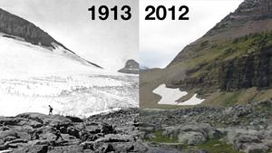
The Vanishing White: How Climate Change is Reshaping Mountain Snowpacks and Why It Matters
373 days ago
The Science of Senescence: Unpacking Autumn's Profound Natural Transformations
371 days ago
Folklore vs. Forecast: Can Animals Truly Predict the Weather? Unpacking the Science Behind Ancient Beliefs
372 days agoFrequently Asked Questions
Learn more about Weatheradar’s weather parameters, their units of measurement, and what values to pay attention to.
Atmospheric Parameters
Pressure refers to the atmospheric pressure at sea level, measured in hectopascals (hPa). Values higher than 1020 hPa often indicate clear skies, while values below 1000 hPa may signal storms or unsettled weather.
Humidity represents the percentage of water vapor in the air. Higher values (above 70%) indicate sticky or humid conditions, often preceding rain or fog.
Temperature Parameters
"Feels Like" accounts for wind chill or humidity, making it feel colder or warmer than the actual temperature. For example, wind can make a day feel colder, while high humidity makes it feel hotter.
The dew point is the temperature at which the air becomes saturated and water vapor condenses. Higher dew points (>20°) indicate humid conditions, while lower dew points (<10°) mean drier weather.
UV and Precipitation
The UV Index measures ultraviolet radiation from the sun. Values 0–2 are safe, while values 6+ require sun protection (sunscreen, shade).
Precipitation Probability is the chance of rain or snow. Values above 50% indicate a moderate likelihood, while values above 80% suggest you should carry an umbrella.